
|
|
Bring your own ropes -- a guide to flying to and in Alaskaby Philip Greenspun in September 2002 |
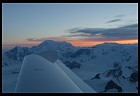 At 10,000' you're shoulder-to-shoulder with waves of snow-capped peaks
that extend to the horizon. You look down at a wide glacier below.
You look up to the scattered lone peaks that poke up to nearly
20,000'. You're not on air traffic control radar and you haven't been
able to reach Flight Service on the radio for 20 minutes. You're
alone among the mountains enjoying views that, without an aircraft,
would require three weeks of trekking and climbing to reach. This is
general aviation in Alaska.
At 10,000' you're shoulder-to-shoulder with waves of snow-capped peaks
that extend to the horizon. You look down at a wide glacier below.
You look up to the scattered lone peaks that poke up to nearly
20,000'. You're not on air traffic control radar and you haven't been
able to reach Flight Service on the radio for 20 minutes. You're
alone among the mountains enjoying views that, without an aircraft,
would require three weeks of trekking and climbing to reach. This is
general aviation in Alaska.
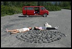
It is impossible to capture the experience of flying in Alaska with a photograph. Up in a small airplane one is immersed in the landscape, not looking at a small square image of scenery. It might be possible to transmit some of the feeling by taking three high-resolution panoramic images from the airplane. Image 1 would be of the sky; Image 2 of the scene straight ahead; Image 3 of the ground below. These images would then be printed 2 meters wide and wrapped around the viewer in a hemisphere.
Basically you have to be there. If you fly your own airplane this article is an attempt to share some of the things that the author learned during a Boston-to-Alaska-and-back trip in June-November 2002.
 Alaska is unforgiving but it need not be challenging. Winds in the
summer are often calm. Runways at public airports are usually paved
and long. Remember that most Alaskan towns are without a highway
connection. Things that a small town in the Lower 48 would get by
truck come in via air freight. You can tour every region of the state
for weeks without landing on a runway shorter than 5000'. Density
altitude is not an issue in Alaska: runways are long, elevations are
usually within a few hundred feet of sea level, and temperatures are
fairly cool even in summer.
Alaska is unforgiving but it need not be challenging. Winds in the
summer are often calm. Runways at public airports are usually paved
and long. Remember that most Alaskan towns are without a highway
connection. Things that a small town in the Lower 48 would get by
truck come in via air freight. You can tour every region of the state
for weeks without landing on a runway shorter than 5000'. Density
altitude is not an issue in Alaska: runways are long, elevations are
usually within a few hundred feet of sea level, and temperatures are
fairly cool even in summer.
The unforgiving aspect of good-weather flying in Alaska stems from the mountainous and sparsely settled nature of the state. Fuel mismanagement and mechanical problems are much more serious when you are 100 miles from the nearest airport. Sightseeing around coastal Alaska involves a certain amount of flying over water that is sufficiently frigid to make a lifejacket a mixed blessing.
Truly bad weather isn't much of a challenge in Alaska, either. The forecast will call for 300' ceilings, rain, and 1 miles of visibility. Most little airplanes won't have sufficient fuel reserves to plan an instrument flight under these circumstances because the nearest suitable alternate airport will likely be 200 nautical miles away. Summer clouds on a bad day can be solid from 2000 to 20,000 feet with a freezing level at 6000' and icing forecast from 9000 to 16,000. The minimum enroute altitudes will be from 7000' to 10,000', i.e., right where the ice can be expected. Because air traffic is so sparse there won't be any pilot reports for your planned route and altitude. If you drive out to the airport you'll find that the scheduled airlines have cancelled all of their flights.
Marginal weather is the most challenging situation for the aviation tourist in Alaska. The local pilots won't think twice about flying up a river valley if there is 500' or 1000' of separation between the ground and the cloud, even if the visibility is low due to rain. These guys know every twist and turn in the path, they know exactly how high they must be to clear the obstacles, and their airplanes are usually sufficiently slow to afford a lot of time to think. The Alaskan employees of the FAA have installed weathercams in many of the mountain passes that serve as transportation corridors for the state. Even if you can't get Internet access as a tourist these views are available to the telephone weather briefers in the flight service stations.
Strong winds aloft on an otherwise clear day can also be considered marginal weather due to Alaska's dramatic topography. Mountain flying is easy if the winds are less than 20 knots: no wind--no mountain wave; no wind--no downdraft on the lee side of a range; no wind--no turbulence in the pass; no wind--no gales coming out of gaps between ranges. Mountain flying becomes tough on the pilot and even tougher on the passengers when the winds pick up. Take some mountain flying lessons or wait a day until the winds die down; high winds depend on strong pressure gradients which by their very nature cannot persist (i.e., eventually the air will all have moved from the high pressure area to the low pressure area).
Another time when patience is helpful is in flight: take it slow in Alaska. A typical local plane is a Piper Cub or a Cessna dragging around a couple of huge floats. These guys aren't going more than 95 knots. This gives them time to enjoy the scenery but, more important, time to evaluate the weather and terrain ahead, and, most important in mountainous areas, a tight turning radius. You'll use up a lot of horizontal distance doing a 180-degree turn in an airplane that is moving forward at 150 knots. If you put out flaps and reduce power until you're moping along at 75 knots your airplane can execute a surprisingly tight turn.
When filing a flight plan in Alaska it is common practice to note in the remarks "following highway" or "following river". If you stick to this route it should be relatively easy for searchers to find you.
From Whitehorse, Yukon, fly low over the highway to Skagway, Alaska and back (1.5 hours). Even when the weather in interior Yukon is good, the weather in Skagway may be bad in which case you can turn around upon reaching the pass. You'll see the usual mountains, glaciers, and lakes plus old mines that are hung on the cliffsides.
From Haines Junction, Yukon, fly west into Kluane National Park to explore the network of wide glacier-carved valleys and mountains that rise to 2000'. Talk to the flightseeing pilots at the airport before departing to mark out a route on a chart. Before taking off program your GPS with waypoints so that you don't get lost in the maze of mountains and valleys. The Haines Junction runway is gravel but has a full lighting system and a VASI. The flightseeing company sells 100LL. Be very careful with the wind here. If it is windy on the ground it may be murderously turbulent in the mountains. Best to go early in the morning or late in the evening (we departed at 11:00 pm in early July and landed at 12:30 am just as it was getting dark).
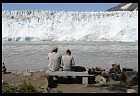
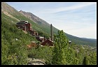
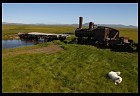
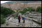
From Anchorage fly over the Portage Pass into the Prince William Sound (0.5 hours), a wonderland of 50 glaciers coming down into the water that was famously despoiled by the Exxon Valdez. Fly at 2000-3000' for the best sightseeing and hug the shoreline in case of engine failure, proceeding east to Cordova, a fishing village that is accessible only by airplane or Alaska Marine Highway ferry boat. The big airport in Cordova has commercial airline service, a 7500' paved runway, and no fuel! (The downtown airport has a short gravel strip and fuel for sale; another nearby alternative for fuel is to stop at Valdez.) Rent a car and drive 50 miles out a well-maintained gravel road to the Million Dollar Bridge where you can watch the 500'-high, mile-wide Childs Glacier calve into a river. This will give you a good look from the ground at the Copper River Delta. Get back in the airplane and fly up the Copper River at 1500' MSL then turn right after about 80 miles to follow another river to McCarthy (4000' gravel; no fuel). McCarthy is the home of the Kennecott Mine, which closed in 1938 but whose massive wooden buildings were preserved by Alaskans and are now part of the Wrangell St. Elias National Park. McCarthy is a great town for hanging out with hippies, letting your dog run free in the streets to make friends with all the other dogs, hiking, and touring the mine. On the way back to Anchorage stop at Gulkana for fuel. You'll need it because it is about 1.2 hours from Anchorage to Cordova, 1.5 hours from Cordova to McCarthy, and maybe 1 hour from McCarthy to Gulkana.
Fly to Nome and rent a car to explore the 300 miles of gravel roads that afford access to the Eskimo village of Teller, abandoned gold dredges, and thousands of square miles of empty tundra. Nome is a town for white people who like the Eskimo world. Continue up the coast to Kotzebue to see an authentic Eskimo town before heading back. You can visit this area from Anchorage, stopping for fuel in McGrath, or from Fairbanks, stopping for fuel in Gulkana.
Visit Brooks Camp in Katmai National Park in mid-July to see 10 brown bears fishing for salmon on a waterfall. Fly your wheeled airplane to King Salmon and take a float plane air taxi to Brooks Camp.

 If you're an expert pilot in a tailwheel airplane equipped with
enormous low-pressure tundra tires and your primary reason for coming
to Alaska is fishing, hunting, or wilderness hiking, that's great.
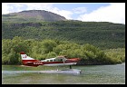
You'll be able to go point-to-point by airplane. Ditto for floats.
If what you really want to do is get into the back country, many times
floats are the only way to get in.
If you're an expert pilot in a tailwheel airplane equipped with
enormous low-pressure tundra tires and your primary reason for coming
to Alaska is fishing, hunting, or wilderness hiking, that's great.
You'll be able to go point-to-point by airplane. Ditto for floats.
If what you really want to do is get into the back country, many times
floats are the only way to get in.
If you're a beginner in a tricycle-gear plane with standard tires you'll have a different trip. You're all set for flightseeing, getting a good look at how the mountains and rivers of Alaska fit together. You're all set for cultural tourism; pretty much any town in Alaska large enough to have a hotel has a reasonably good airport. If want to get into the back country you can always hire a local air taxi to drop you into the location of your choice.
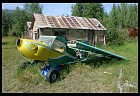
I did the trip in a brand-new Diamond DA40, a tricycle-gear composite aircraft with a composite prop, having left Boston with 130 hours of total flying experience. Despite operating from gravel runways at least 15 times, the DA40 hardly picked up any nicks or dings.
You'll also want to prepare a survival kit before venturing into the wilderness areas of Canada. The contents of this kit is governed by Alaska Statutes Sec. 02.35.110, which as of 2002 reads as follows:
Emergency rations and equipment.

(a) An airman may not make a flight inside the state with an aircraft
unless emergency equipment is carried as follows:

 (1) the following minimum equipment must be carried during the summer months:

    (A) rations for each occupant sufficient to sustain life for one week;
    (B) one axe or hatchet;
    (C) one first aid kit;
    (D) an assortment of tackle such as hooks, flies, lines, and sinkers;
    (E) one knife;
    (F) fire starter;
    (G) one mosquito headnet for each occupant;
    (H) two small signaling devices such as colored smoke bombs,
    railroad fuses, or Very pistol shells, in sealed metal containers;

 (2) in addition to the equipment required under (1) of this subsection,
     the following must be carried as minimum equipment from October 15
     to April 1 of each year:

    (A) one pair of snowshoes;
    (B) one sleeping bag;
    (C) one wool blanket or equivalent for each occupant over four.
Unless you're flying a Cessna Caravan, a good place to shop for survival gear is a backpacking/mountaineering store. The junky camping gear that they sell at Walmart is simply too heavy for most small airplanes. Consider supplementing the legal minimum gear with a backpacking tent, emergency shelters (mini tents), down sleeping bags, and foam pads, even in summer. You might have to put the airplane down on a glacier and it can be cold and wet at any time of year. Almost any time that you go into the Alaska wilderness it is worth bringing a rented Iridium satellite phone from www.satphonestore.com.
If you're going to be getting any avionics work done on your airplane, consider installing a 406 MHz ELT:
 If you're from the Lower 48, also known to Alaskans as "Outside",
you'll be flying through Canada in order to get to Alaska. Sadly
there don't seem to be any good pamphlets explaining to U.S. pilots
how to behave in Canada. Below are some of the differences that
you'll notice.
If you're from the Lower 48, also known to Alaskans as "Outside",
you'll be flying through Canada in order to get to Alaska. Sadly
there don't seem to be any good pamphlets explaining to U.S. pilots
how to behave in Canada. Below are some of the differences that
you'll notice.
Many airports in Canada have on-field flight service stations that monitor the common traffic advisory frequency (CTAF). Sometimes this frequency is referred to as "the mandatory frequency" and indeed, though the airport is not tower-controlled, you are required to call for advisories when inbound for landing or when taxing for takeoff. The flight service personnel will give you the local altimeter setting and tell you about other known traffic but they aren't responsible for traffic separation. Your radio calls will start "Ft. St. John radio..." if the flight service station is staffed or "Ft. St. John traffic" if they've gone home for the night.
Filing a flight plan is mandatory for trips of more than 25 nautical miles. This may seem onerous, particularly because Canada uses the ICAO flight plan format instead of the FAA format. However, the flight service personnel are usually much friendlier than their US counterparts and they are quite happy to prompt you through each question on the form. Moreover, the definition of "flight plan" is rather loose. If you've left a description of your route and a projected arrival time with your mother, that counts as a flight plan. You need not actually contact flight service. If you do decide to use Canadian flight service to hold onto your VFR flight plans they will make life easy for you by opening and closing them automatically.
Don't turn your strobes on until you're actually taxiing onto the runway.
Engrave 126.7 into your brain. This is the enroute flight service frequency in Canada and oftentimes it is the only frequency monitored in remote areas. Unlike their U.S. counterparts the Canadians don't seem to monitor 121.5 at every flight service RCO. If you want to make position reports or call for help, 126.7. This frequency is not on the charts.
It is tough to buy the Canadian equivalent of the US AFD (airport facilities directory). If you get the Jeppesen IFR trip kit for Western Canada it comes with an abbreviated AFD in the front, covering VFR-only and IFR-capable airports.
Don't be shy about asking the Canadian flight service folks lots of questions. The Canadians are quite indulgent of clueless Americans flying around in their country. Moreover the Canadians don't have supervisors who can monitor their phone conversations and fire them if they don't stick to business. The Canadians have much more local knowledge and are a lot more flexible than US Flight Service. In the wilder areas of the country they will know the names and phone numbers of the people who sell Avgas at various fields.
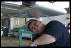 Merrill Field in Anchorage is the easiest place in which to get work
done on your airplane. Aerotwin was the maintenance shop recommended
by several locals and indeed their work on my Diamond Star was done
promptly, competently, and at a fair price. Northern Lights Avionics
is the best pilot shop in Anchorage and also has several really good
radio technicians. Take Flight Alaska is a good flight school at
Merrill but in 2002 they weren't doing instruction in owners'
airplanes.
Merrill Field in Anchorage is the easiest place in which to get work
done on your airplane. Aerotwin was the maintenance shop recommended
by several locals and indeed their work on my Diamond Star was done
promptly, competently, and at a fair price. Northern Lights Avionics
is the best pilot shop in Anchorage and also has several really good
radio technicians. Take Flight Alaska is a good flight school at
Merrill but in 2002 they weren't doing instruction in owners'
airplanes.
As you proceed north from Alberta and British Columbia, do prepare yourself for a reduction in services at airports. After you land in a typical Lower 48 airport the line guy from the airport gas station (FBO) runs out to park your airplane, tie it down, top off the tanks with gas. Would you like to borrow the courtesy car to go into town? Would you like some fresh-baked cookies? To take a shower in the pristine bathroom? A typical Alaska experience involves pumping your own gas from some self-service pumps, peeing into the weeds, and discovering that only a handful of the tiedown rings have any ropes attached, all of them frayed.
In the Lower 48 airplanes are for rich people and rich companies. The average small plane that comes in will be a $5 million jet delivering the CEO's kids to their horseback-riding camp or a plastic surgeon goofing around in his brand-new $300,000 Cirrus. These are people who value their time and comfort and don't mind paying an extra 5 cents per gallon for fuel. In Alaska by contrast the average plane is a 40-year-old Cessna piloted by a plumber. For him the $35,000 airplane is the only way that he can get to his customers and he doesn't want to pay for a lot of extra services. Imagine visiting an automobile parking lot circa 1920. Cars were for rich people and you'd expect the attendants to run out, wash the car, gas it up if necessary, etc. But today everyone has a car and if you pulled your Ford Pinto into a downtown lot you wouldn't expect the attendant to speak English, much less perform any services beyond taking your money.
Basically if you have time and money you can fly safely to, from, and within Alaska with almost any level of piloting experience. You'll probably be a lot less frightened if you've already got an instrument rating. You may want to find local pilots to fly with at various stops. You may want to hire an instructor to build up your mountain flying skills. But if you're a reasonably cautious person there is every reason to expect that you'll make it back alive.
After not seeing an update for so long, and with the tragic news of the Rowell's, I was worried about you Phil. Glad you're home and safe. I look forward to more content! OT: Did you take any pictures while in Portland (OR)? I'd like to see what you found note-worthy in my part of the world.
-- dan stark, November 19, 2002
Thanks for the good wishes, Dan. My friend Jin joined me for the last leg of the Boston-Alaska-Baja-Boston trip. I picked him up at BWI and we landed at Logan airport (they made a United Airlines 757 wait on a taxiway while we putted down the glideslope for 04L). After we got out of the plane he said that he'd been giving me 3:1 odds on making it back to Boston alive. I do feel lucky not to have ended up like Galen Rowell though of course he was in a much higher performance airplane than my DA40.Sorry but no pictures of Portland: (1) this trip was not about photography, and (2) we didn't stop in Portland because the Winnebago is not the ideal vehicle for city sightseeing, I've been to Portland a few times before, and also we were anxious to get to the California coast.
-- Philip Greenspun, November 20, 2002
This is Philip Greenspun's sister at the keyboard. I hadn't really calculated the odds, but was loathe to see him take off from the DC area last May enroute to Canada/Alaska. I'm in favor of Philip selling the airplane and doing something completely different. He is meant to be a wonderful uncle to my four boys, one of whom is almost anatomically attached to a computer Philip sent him back in March as a Bar Mitzvah gift. I do not delude myself that Philip will ever be as good-looking or famous as JFK, Jr., but I don't want him to go down in an airplane with two screaming women in the back seat asking him "What the hell is going wrong?" (that would be supermodel wife and investment banker sister-in-law) We love you, Philip! By the way, hubby thinks flying back and forth across the country and having to deal with government workers like air traffic controllers brought you back-down-to-earth, so was well worth the trip! -- Suzanne nee Greenspun Goode, Bethesda, Maryland
-- suzanne goode, November 22, 2002
Philip, your sister is communicating with you via web-page. That's somewhat reasonable for people that have only met you once or twice (like me) but does seems worrisome in her case. =^) PS. As always I enjoy reading about your adventures. Say "Hi" when next in Boston.
-- Alexander (Sasha) Wait, December 9, 2002
A quick comment on flying in Canada and the local AFD equivalent;
In Canada, the aerodrome / airport listings and information is compiled in a document called the "Canada Flight Supplement".
Most pilot supply stores will sell these, along with current VFR and IFR charts and procedure plates. The retail going rate is around 25$ CAN for the CFS. Unlike the US AFD, the CFS covers ALL of Canada. If you need a waterdrome supplement, it is published annually in a separate publication.
More information on the CFS can be found at the Canadian Government's Natural Resources Canada Aeronautical and Technical Services' CFS page.
In addition, the CFS has a section dealing with ICAO / Canadian format flight plans.
Hope this helps.
Alan Hawrylyshen
-- Alan Hawrylyshen, December 16, 2002
Philip, I really enjoyed this and related pages and had been wondering how the trip to Alaska went. I visit photo.net frequently but had never seen any of this featured. I would personally like to see your more obvious presence on photo.net again, or at least a more obvious link to what you have been doing lately with regard to photography.
-- Landrum Kelly, February 21, 2003
The frequency 126.7 referred to in your article is no longer used for Flight services due to congestion in many areas. The best way to get the correct frequencies for flight services in the area you are flying through is from a book called the Canadian Flight Supplement, or from an app like foreflight. (if you are flying through Alberta or parts of Saskatchewan, look up "Edmonton Radio" If you are flying through BC, look up "Pacific Radio" Mannitoba and Saskatchewan, look up "Winnipeg Radio" and so on.No longer valid..."Engrave 126.7 into your brain. This is the enroute flight service frequency in Canada and oftentimes it is the only frequency monitored in remote areas. Unlike their U.S. counterparts the Canadians don't seem to monitor 121.5 at every flight service RCO. If you want to make position reports or call for help, 126.7. This frequency is not on the charts."
-- Jonas Boll, October 28, 2015