Avidyne versus Garmin G1000 glass cockpits
a comparison by Philip Greenspun; updated June 2008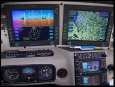
Avidyne versus Garmin G1000 glass cockpitsa comparison by Philip Greenspun; updated June 2008 |
|
Avidyne and Garmin are the two leading manufacturers of inexpensive glass cockpits for small airplanes. Avidyne was the first to market with a primary flight display (PFD) and its system was adopted by Cirrus and Piper. The Garmin G1000 system followed and was adopted by Beech, Cessna, and Mooney. Columbia/Lancair and Diamond initially offered Avidyne, but both switched to the Garmin G1000. In May 2008, Cirrus announced a Garmin G1000 option for its SR22.
As you move up to move advanced planes, the Garmin G1000 becomes overwhelmingly dominant. Nearly all of the very light jets use the G1000 and Garmin autopilot. The TBM850 personal turboprop started shipping with the G1000 in 2008.
This review is based on more than 350 hours of Avidyne usage in a 2005 Cirrus SR20, about 50 hours with the G1000 in a 2005 Diamond DA40, 3.6 hours in a Cessna 182/G1000 with in-flight weather, and a few hours in a Cessna Mustang.
A typical Avidyne installation includes the following boxes in the airplane's panel:
The G1000 does so much that it may do more or less depending on the airplane in which it is installed. In some planes, for example, the G1000 will be the only place to look for engine data and fuel tank state. In some planes, the autopilot will be loosely integrated whereas in planes using the Garmin autopilot, the integration will be complete.
Nearly all G1000 installations should eventually get a synthetic terrain option, announced by Garmin in April 2008. A person who didn't know anything about aviation would ask, upon entering the clouds, "How come these big computer screens can't show the surrounding mountains, obstacles, and other airplanes?" Microsoft Flight Simulator does it for $45. www.bluemountainavionics.com does it for experimental airplanes. VistaNav introduced a portable system for less than $5000 some years ago. Chelton Flight Systems did it for NASA and as a retrofit for certified airplanes starting around 2003. With the G1000, synthetic terrain will enter the mainstream.
What will it cost to add the capabilities of Microsoft's $45 product to a four-seat single-engine airplane? The price will vary depending on the manufacturer, but pricing for the G1000's synthetic terrain software upgrade has generally been around $10,000.
Will synthetic terrain increase safety for instrument flying? Experienced airline crews have flown into mountains when attempting non-precision approaches and having one instrument set up to the wrong frequency (example: American Airlines 965). Ten-year-old kids don't fly into mountains when they're using Microsoft Flight Simulator. Why not? They see the mountain, add power, and pull up.
The Avidyne HSI is much better than the G1000 HSI in important ways, which is odd because Garmin had two years to study how the Avidyne worked. The wind vector on the Avidyne and the schematic map are wonderful features. The Avidyne HSI has a faint dashed white line showing GPS-predicted track, which is very useful when trying to find the right heading coming down an ILS as the wind shifts. The G1000 offers the same information, but only on the MFD moving map, which is not where one ought to be looking on an ILS approach.
Especially with Release 6 of the Avidyne MFD software, the presentation of weather information received from the XM satellites is quite nice. If you scroll among the nearest airports, you see their METARs. If you look at your flight plan, you can scroll from one waypoint to the next, seeing METARs at every stop. Garmin's weather page, by contrast, is an island unto itself. If you're looking at an airport in a nearest or flight plan view, there is no way to see its current weather.
The lack of a cursor or a touch screen is very frustrating. You can see things on the map, e.g., airports, roads, but there is no way to point to one and ask for more information about it, as you can do with the Garmin 430/530 (clumsily) and the G1000 (reasonably easily).
An airline pilot buddy complained of the lack of an airspeed bug to help with holding a constant airspeed for performance or air traffic control (ATC) reasons. Right after he uttered his complaint, ATC instructed us to "maintain this airspeed until BEDDS". [The Garmin has airspeed bugs.]
In the Cirrus SR2x airplanes, the installation of the Avidyne as the autopilot's altitude preselect control resulted in the removal of the altitude alert function that most autopilots provide and that is required for jet airplanes by FAR 91.219. If you are drifting off your assigned altitude, or coming up to within 1000' of your final clearance altitude, you will not get a beep from your avionics, as you would in a typical autopilot-equipped steam gauge airplane.
Another thing that I always hated about the 430/530 was how they would squeal at you about airspace when you were flying IFR. Each ring of a Bravo airspace is modeled separately so flying from Boston to Washington, D.C., for example, you'd have to press the MSG button literally almost 200 times to acknowledge and clear various warnings. Turning off the airspace alerts involved quite a bit of gymnastics on the AUX page and you'd probably forget to turn them back on next time you went out VFR. The G1000 fixes this issue with pilot profiles that store custom settings. I would use this to store "philip-ifr" and "philip-vfr" profiles, with the airspace warnings disabled for "philip-ifr". (The G1000 manual included with the Cessna 182/G1000 describes this feature, but an entire block of the system setup page was missing on that aircraft and the owner and I were unable to figure out a way to bring it up. The pilot profiles work fine in the DA40.)
For regularly adjusted items, the G1000 has dedicated, single-purpose knobs. Where the Avidyne will have you press a labeled soft key to select a mode and then adjust one of only two knobs, most of the (numerous) knobs on the Garmin always adjust the same thing, e.g., heading for the knob labeled "heading".
The G1000 audio panel has a "playback" button that plays back the last handful of calls from the radio, which could be very useful for teaching students. [JFK, Jr. had a similar device in his Piper Saratoga, part of a $300 panel clock, which led conspiracy theorists to talk about his plane being equipped with a cockpit voice recorder, like an airliner, and why weren't the recordings recoverable like those from an airliner's black box?]
The airspeed tape has little adjacent v-speed bugs for Vx, Vy, best-glide, etc. The G1000 has a fuel totalizer and the fuel gauges and ought to know how many gallons are in the plane at all times. You would think that you would tell the G1000 the total weight of passengers and bags and then it would continuously update the V-speeds in flight. Sadly, however, the G1000 does not compute these for you and you are expected to adjust them in flight.
The Garmin MFD displays an endurance circle of all the places you can go before running down to 45 minutes of fuel and a wider one of the places you can glide to with empty tanks; this "circle" is actually stretched out of shape depending on the winds aloft.
The primary flight display (PFD) offers an inset map that can show traffic, terrain, or just waypoints and the flight plan right next to the HSI.
The inset map on the PFD is stuck at the same orientation as the big map on the MFD; this prevents you from having one map "north up" (for communication with ATC when they ask for your position relative to other stuff) and one map "track up" (for figuring out where stuff is relative to where you are going); an Avidyne/Garmin 430 system would typically have four moving maps (waypoints inset into the HSI on the PFD, fixed at Track Up; big MFD map, smaller maps on each of the two 430s, all three of the latter configurable track up or north up).
The fuel tank gauges in the G1000/DA40 installation are small, about the same size as the ammeter and other non-critical gauges. I.e., they are not prominent enough considering the dire consequences of running out of fuel. There is no digital readout of the fuel quantity in the two tanks unless you use the soft keys to go down a page. Garmin could easily have made the fuel gauges grow to occupy more screen real estate as the fuel got below, say, 5 gallons, in either tank or more than 10 gallons out of balance. Instead, the fuel gauges stay tiny whether or not there is any critical action to be taken.
The engine gauges in the DA40 installation of the G1000 display manifold pressure and prop speed, but not percent of engine power, as the Avidyne E-Max system does on the Cirrus; in the Diamond you are supposed to pull out the paper owner's manual and leaf through it to calculate the percent power.
If you drill down a bit with the soft keys, pressing "Engine" and "System" to get some more precise numbers, you get to a page where the fuel gauges are not displayed at all. The G1000 will stay on this page indefinitely. I.e., it is possible for someone who presses two buttons to fly a G1000-equipped aircraft for several hours without any fuel gauges being displayed.
The wind vector on the Garmin it is stuck into the inset or MFD map and the direction is not available as a number except possibly on a subpage somewhere.
In-flight weather is one of the most important innovations in small airplanes in the 21st Century. Garmin's presentation of this information is one of the clumsiest software development efforts that most pilots are likely to have seen. Scroll among the nearest airports. Wouldn't you expect to see their METARs, as on the Avidyne? You won't. You have to go to a separate weather chapter on the MFD and roll the cursor precisely over an airport. How about the METAR at your destination airport? Wouldn't you expect to see this in the Waypoint or Flight Plan pages? You won't.
Similarly for entering a frequency into COM 2. With a traditional radio stack, you reach over to COM 2, which is probably underneath COM 1 and labeled "COM 2". You twist the knob that is always there and that always adjusts the COM 2 frequency. With the G1000, you study the COM freqencies display (typically four numbers) and figure out which number is surrounded by a box. This is the number that you are going to be changing if you twist the COM knob. If the box isn't surrounding the number you want to change, you have to think long enough to push the COM knob to toggle between "I'm adjusting COM 1" and "I'm adjusting COM 2" modes.
A 1965 Cessna has what computer nerds would call a "modeless interface". Each switch and knob does one thing and it is the same thing all the time. This is a very usable interface, but it doesn't scale up very well, as you can see by looking at the panel of a Boeing 707. Both the Avidyne and the G1000 have some modal elements. Knobs and switches do different things at different times. The G1000 is more deeply modal and therefore, I think, will always be harder to use.
The Garmin G1000 is designed for in-flight restarts and, in my experience, has been 100 percent reliable in coming back to life after a breaker was pulled and reset.
The G1000 has a true/magnetic switch for the entire system, just like the big Boeings, and is right at home in the Arctic.
If the Avidyne PFD screen or its backlight fails, or the Avidyne PFD software and hardware malfuctions, your only alternative source of information will be the steam gauges and the GPS units. In the Cirrus, for example, you will not be able to do an ILS approach because you won't have any indicator for the localizer or glide slope.
In 300 hours of using the Avidyne, I have experienced at least three total failures of the PFD and several total failures of the MFD. In more than 2000 hours of using Garmin GPS units and the G1000, I have never experienced any problems.
My friends who have the Avidyne MFD in their older Cirruses report that it is one of the least reliable components in the airplane, with units typically failing and requiring replacement on average every 150 hours.
In our Cirrus, the Avidyne PFD/MFD has been responsible for more time in the shop than any other system. Imagine if every time you needed a software update for your desktop computer you had to take the computer to a government-certified mechanic who would use tools to remove a portion of that computer and send it back to the manufacturer. The manufacturer would then perform a government-regulated software update and return the subunit, with a pile of government-required paperwork, to your government-certified mechanic. Your government-certified mechanic would reassemble your computer and return it to you with some logbook entries. That is what it is like to depend on an ambitious collection of computer software that is running behind the instrument panel of a certified aircraft.
When I wanted a circuit board upgrade to a Garmin audio panel, the company was able to turn my GMA 340 around in two business days. In January 2006, Avidyne promised to upgrade the software on the PFD and MFD within two calendar weeks, but the airplane ended up being unavailable for more than three weeks due to delays and shipping. Other Cirrus owners have reported delays of more than five weeks for the same software upgrade.
Over a seven month period, Avidyne did not have any suggestions for how to stop the PFD in my Cirrus from red-screening or the MFD from seizing. Eventually, however, they came out with a new release of the software that they thought might fix the problem and invited me to pay them $500 to install the upgrade. I inquired as to whether this might be covered under the airplane or the avionics warranty, but both Avidyne and Cirrus said no.
How about Avidyne installations in other types of airplanes? Here's a posting from a Piper Malibu and Meridian owner's forum: "I recently purchased a Meridian [$2 million turbine-powered 6-seater] with the Avidyne package. The large screen and C-Max are great. I have not been impressed with the customer service of Avidyne. My plane was down for a week and a half recently with problems. The turnaround time on reparing a unit is about a week. Their website claims 24-hour turnaround, but a tech informed me that that was no longer the case."
Avidyne was a flagship provider of avionics to Eclipse for its revolutionary very light jet. The companies had a messy public divorce in February 2007, with Eclipse blaming Avidyne for certification delays. In November 2007, Vern Raburn, the founder and CEO of Eclipse, said "this flight also made it clear to me that parting ways with Avidyne was one of the best decisions we've ever made. Besides an inability to deliver on promised functionality, initial in-service reliability data shows that Avidyne hardware is consistently at the top of the charts for failures for systems on the airplane."
If the COM 1/2 split button doesn't have any effect, and it is disabled by default on the Diamond Star DA40, go to an avionics shop and see if they can enable it from a setup page so that you can talk and listen on COM 1 while your copilot can talk and listen on COM 2.
The Garmin G1000 with synthetic terrain should offer a very different flying experience under instrument conditions, with highway-in-the-sky guidance through procedures and a constant easy-to-interpret reminder of the location of obstacles and terrain.
Here's what the Garmin G1000 has going for it:
I really wished I understood how Garmin comes up with the bizarre design decisions. Apparently, ease of certification is a major factor....
-- Christian Goetze, April 10, 2006
Some points I'd like to make.1. NDB/ADF. In the "rest of the world" (i.e. not USA) the majority of terminal & en-route navaids are still the humble NDB. RAIM outages often coincide with passenger's "gotta get there by whenever" so RNAV(GNSS) cannot be always relied on. In Australia, many routes are defined from NDB to NDB and often include ded-reckoning sectors -- even tracking between NDBs you may be out of range of either station. Several of these sectors are over desert or the Pacific Ocean, and may correspond with RAIM outages for at least part of the time (Murphy's Law).
So, the key requirement here is integrating ADF receiver(s) display / pointer with the HSI. Can any of the Chelton / Avidyne / Garmin units do this? And, when NDB is the sole available aid, two working units are required unless its a private flight.
As far as I'm aware, only the Sandel SN3500 & SN4500 display ADF data on an HSI.
2. DME is required for many ILS approaches. Unless the chart is notated "GPS can be used for DME" then you must have DME.
So, the key requirement here is integrating a DME receiver & display NM display (minimum) with the HSI. Can any of the Chelton / Avidyne / Garmin units do this?
Again, as far as I'm aware, only the Sandel SN3500 & SN4500 display DME data on an HSI.
3. Upload / download data from panel-mount systems. A particular annoyance is using a flight-planning tool to compute a course with forecast weather, actual loading and fuel -- then having to painstakingly enter all this good data into the GPS integrated system.
Given the universal availability of BlueTooth on all late-model Notebook and Tablet computers, and on the more capable PDA's, a BlueTooth upload / download capability is not optional but essential, especially when the asking price for all this panel mount gear is north of US$50K.
4. Has anyone owned / used / tried the Garmin GNS480 or its siblings? How does this work c.f. the GNS4xx/5xx family?
-- Laurence Burrows, December 18, 2006
Laurence wrote that "DME is required for many ILS approaches. Unless the chart is notated "GPS can be used for DME" then you must have DME."
This is actually incorrect. I hesitate to say that all new GA singles with glass are not equipped with DME, but I'm fairly certain that it's the case. If you have a GNS 430 or equivalent nav/com, there is no DME installed. What you're claiming means that nobody owning a GNS430/530 or G1000-equipped aircraft - essentially every GA single sold for the past five or more years - is unable to shoot about half of the ILS approaches currently in service.
AIM 1-1-19 (f. Use of GPS in lieu of ADF and DME) determines what fixes and equipment IFR-approved GPS can be substituted for (ADF and/or DME in general), and it's a pretty liberal list:
(a) Operations allowed:
(1) Determining the aircraft position over a DME fix.
(2) Flying a DME arc.
(3) Navigating to/from an NDB/compass locator.
(4) Determining the aircraft position over an NDB/compass locator.
(5) Determining the aircraft position over a fix defined by an NDB/compass locator bearing crossing a VOR/LOC course.
(6) Holding over an NDB/compass locator.
-- eric gideon, April 30, 2007
Regarding the GNS480 - GNS430/530 interoperability question; I have learned that there is no crossfill capability between a GNS480 and a GNS430/530 as there is between the 430 and 530 combination installation.
-- Scott Beck, January 19, 2008
First of on the CESSNA's the G1000 has victor airways on the maps. second, you can enter your flight plan using victor airways. third, the fuel gages have ALWAY BEEN IN VIEW!! on the PFD or MFD no mater what page you are on. forth, if you do not have victor airways on you map if you are flying a Cessna than you have the WRONG software which is old installed on the plane.
-- john jones, March 11, 2008
DME and ADF are options for all G1000 Cessna's and have been for some time now.
-- john jones, March 11, 2008
Well it had to happen, Cirrus is now using the G1000 Avadied days are numberd.
-- john jones, May 20, 2008
With regards to your comment on the Garmin G1000 and weather you say: "Wouldn't you expect to see this in the Waypoint or Flight Plan pages? You won't."Well, actually, you do. Just go to either the Waypoint or the Flight Plan page and hit the "WX" soft key. It's there under airport info. On the waypoint pages it's on the main display page. Off of the Flight Plan pages you have to hit "enter" on the airport, bring up the airport information page (same as what's on Waypoints) and hit the "WX" soft key.
-- Peter Marx, August 24, 2008
Also "The wind vector on the Garmin it is stuck into the inset or MFD map and the direction is not available as a number except possibly on a subpage somewhere."Actually you have three options including two displaying the cross-wind components.
-- Peter Marx, August 24, 2008
Seems like we're on a roll.Your wish-list items:
" * you should be able to enter Victor airways on a flight plan and these should be shown clearly on the MFD, with minimum enroute altitudes * all of the fancy screens give you no vertical guidance on approaches; this doesn't really matter for an ILS, but for a non-precision approach it would be so useful to have a text readout "you've passed the FOBAR waypoint, now you can descend to 2000' MSL" (possibly with an alert if the integrated altimeter gets below 1900' MSL on this segment)"
Both are on the latest update from Garmin for the DA-40. You have Victor airways displayed and easily used, as well as full VNAV guidance (at least for descents). There is no VNAV guidance ascending, weirdly, since the G1000 doesn't have any airplane performance data (a miss-step which also rules out W&B, real fuel calculations, etc.).
-- Peter Marx, August 24, 2008